
Historic hills of Waltham
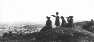
Numerous hills dominate the landscape of Waltham on the north side of the Charles River. Their elevations range from 140 feet to 480 feet above sea level. Hilltops are important features in a city's landscape. In fact, in the planned capital city of Canberra, Australia, American architect Walter Burleigh Griffin had laws passed banning development of the city's hills. Regrettably many of Waltham's hills have been spoiled by unsightly developments. However, some wonderful hills still survive and provide dramatic backdrops, hiking trails, picnic sites and scenic lookouts.
Prospect Hill
First mentioned in 1669, this 482-foot hill is the second highest in the Metropolitan Boston area. At the instigation of Charles Eliot, a 250-acre park was set aside for public pleasure in 1893. Although the 20th century saw some encroachments at its western base, and towers marring its summit, the Prospect Hill Advocacy Group has been active in lobbying for a master plan to restore the park's natural features. The Walker-Kluessing Design Group has created an award winning master plan, which calls for the restoration of the parks's historic features. A long-abandoned Air Force tower at the summit will either be dismantled and the summit restored, or possibly used by the city.
Mackerel Hill
Named in 1650, possibly for a town in England, much of this 300-foot hill located along Trapelo Road is included in the DCR Beaver Brook North Reservation.
Read more about Water Sites, Wetlands, Woods and Hills.